Guidelines for
Drone Geophysics
Sign up now to download and view the most recent Guidelines for Drone Geopyshics!
What are the Guidelines?
The Guidelines for Drone Geophysics is a geophysical industry grass roots initiative to develop and distribute a set of method specific guideline documents on the use an small unoccupied aerial system (sUAS) commonly referred to as a “drone” configured with a payload for measuring and recording geophysical data. The primary objective of the initiative is to educate the practitioners offering drone geophysical mapping services as well as to inform the customers contracting drone geophysical mapping services in the “best practices” for collecting and processing geophysical data. Press the button below to learn more or to provide comments and suggestions to the Committee for Guidelines for Drone Geophysics. We welcome and very much appreciate your input.
Flight & Safety Operations
Safety should be a paramount concern for anyone engaged in drone flight operations for the purpose of geophysical data collection at all times.
The Flight Safety Foundation, an independent impartial international organization focused on aviation safety published the Basic Aviation Risk Standard (BARS) for drones. Click on the button below to download.

The International Airborne Geophysical Safety Association (IAGSA) published a safety recommendation statement for remotely piloted aircraft systems. Click the button at the bottom below to visit the IAGSA website.
2.6 Remotely Piloted Aircraft Systems (RPAS)
Remotely piloted aircraft systems (RPAS), often referred to as drones, are increasingly used for geophysical survey purposes. IAGSA believes that RPAS operations should be held to the same standard of safety as traditional helicopter and fixed wing surveys. IAGSA recommends: All Airborne Geophysical operations utilizing RPAS should be conducted by RPAS operators li[1]censed by the local aviation authorities and who have a documented framework in place to manage risk. The framework should include:
- A maintenance program that includes a release to service under a system of maintenance / Inspection regime,
- Risk management processes including safety reporting and operational risk assessments; particular attention should be given to managing risks associated with maintaining separation between RPAS and manned aircraft,
- Flight planning procedures that address RPAS weight and balance, fuel planning, and weather conditions for the flight,
- A Fatigue Management Plan that addresses workloads for the pilot and other members of the RPAS operations team,
- Fuel quality control procedures, and
- Battery management protocols.
We highly recommend visiting the United States Federal Aviation Administration (FAA) website. The site is a primary resource on the rules and recommendations for safe flight operation in the USA. Much of the content conveyed on the website is applicable for flight operations outside of the USS. Click on the button below to go to the UAS part of the FAA website.
- the USS. Click on the button below to go to the UAS part of the FAA website.
Magnetics
Magnetics is the most globally applied drone geophysical method. It is considered by many professional geophysicists as a basic geologic mapping tool and, as a result, is very often the first geophysical method to be applied when the mission is to explore for base and precious metal deposits to map geology hosting geothermal energy, groundwater, and hydrocarbons. Drone magnetometry is widely known and accepted as a cost-effective method for detecting and delineating legacy oil and gas wells and pipelines as well wide area scanning for presence of unexploded ordnance (UXO) and other ferromagnetic objects.
Click the “download” button to download the Guidelines for Drone Magnetics as a PDF file.
Click on the YouTube Webinar to view the webinar launching of the Guidelines for Drone
Magnetics.
Time Domain EM
The section is about the electromagnetic induction (EMI) of the earth using a pulsed electromagnetic field and measuring the reducing secondary magnetic field after turning transmitted EM pulse off. The focus will be on off-the-shelf commercially available geophysical measurement systems for use with a small UAS, i.e. a drone with a maximum takeoff weight (MTOW) less than 25 Kg. The uses cases for frequency domain EM systems includes but is not limited to resource exploration, environmental, agriculture, and infrastructure sectors.
The Guidelines for Time Domain EM Geophysics are in the early days of development. We anticipate a draft version of the document available for download on or before September 2023. The Committee needs of content authors assist with the document development and reviewers to proofread and suggest edits for the document. Please consider joining the subcommittee. To do so, click on the button below.
Frequency Domain EM
The section is about the electromagnetic induction (EMI) of the earth at discrete sinusoidal frequencies between 1 hertz to 100,000 hertz. The focus will be on off-the-shelf commercially available geophysical measurement systems for use with a small UAS, i.e. a drone with a
maximum takeoff weight (MTOW) less than 25 Kg. The uses cases for frequency domain EM systems includes but is not limited to resource exploration, environmental, agriculture, and infrastructure sectors.
The Guidelines for Frequency Domain EM Geophysics are in the early days of development. We anticipate a draft version of the document available for download on or before September 2023. The Committee needs of content authors assist with the document development and reviewers to proofread and suggest edits for the document. Please consider joining the subcommittee. To do so, click on the button below.
Gamma Ray Spectrometry
Airborne Gamma Ray Spectrometric measurements of Total Count (TC), Potassium (K), Uranium (U), and Thorium (Th) using a small unmanned aerial system (UAS) is an emerging technology with numerous applications in the resource exploration, environmental, agriculture, infrastructure, & security sectors.
The Guidelines for Drone Gamma Ray Spectrometry is presently under
development. We anticipate a draft version of the document available for download on or before April 2023. The Committee needs of reviewers to assist with the document development and reviewers to proofread and suggest edits for the document. Please consider joining the subcommittee. To do so, click on the button below.
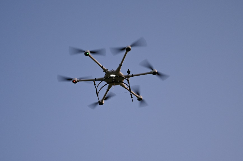
Drones
Though often referenced by a multitude of monikers and initials, in today’s world everyone knows what is meant when term “drone” is spoken. It is, plain and simple, a remotely piloted aircraft. All geophysical surveys are accomplished using a small unoccupied aerial system (sUAS) aka “drone”, capable of being pre-programmed for autonomous flight. Most geophysical mapping surveys are accomplished with a off the shelf, commercially available drone. Nevertheless, some operators prefer to build their own.
Many photogrammetric mapping surveys are accomplished using a fixed wing drone. When it comes to geophysical mapping, most are accomplished using a rotary wing aircraft having multiple rotors, what some in the industry refer to as a “multi-copter”. Of course, there will always be exceptions. The choice of which drone to deploy depends on many factors including the payload lift capability, flight characteristics, and cost.
This section is intended to present the commercially available sUAS and not as an endorsement of any drone. We envision this section as an information resource for those wishing to learn more about the aviation technology for collecting geophysical data.
Visit Our YouTube Channel
Yes, the Guidelines for Drone Geophysics has a YouTube Channel. We invite you to check it out by clicking the button below.
Soon after conducting a webinar to formally launch the Guidelines for Drone Magnetics on November 12, 2022, the entire video was uploaded to channel for anyone interested in learning about drone magnetics to watch, free of charge.
As the other guidelines become available, the recording of the launch webinar will be uploaded to the YouTube channel. If you see endless possibilities for the channel, we agree. If you would like to explore the possibilities, please send an email to ron@dronegeosci.com or terraentheosgeoscience@gmail.com.
We look forward to hearing from you, soon.
Regulations
Around the globe the air space is regulated. Typically, the regulatory body is an agency of the government for the country under which the air space is located. For example, in the United States, Federal Aviation Administration (FAA) published and enforces the regulations on the aircraft, including remotely piloted aircraft occupied the National Air Space (NAS). Below is a link to the UAV part of the FAA website.
As this website evolves and matures, we will include links to the air space regulatory agencies for other countries. Please let us know your suggestions for links you wish to see included on the Guidelines for Drone Geophysics website to ron@drongeosci.com or terraentheosgeoscience@gmail.com.
Sponsors
The Guidelines for Drone Geophysics is a grass roots initiative with the goal of educating the practitioners and informing the customers of drone geophysics. To accomplish the goal, the following individuals and companies have provided the necessary financial support to cover the cost of website, administration, and other costs. We, the Committee, are sincerely and deeply express our heartfelt gratitude for willingness to sponsor this initiative.
Supporting Societies, Associations, and Institutions
The Guidelines for Drone Geophysics is a grass roots initiative with the goal of educating the practitioners and informing the customers of drone geophysics. To accomplish the goal, there must be support from the professional community as well as the those working in academic and research institutions. Following are the societies, associations, and institutions that have agreed to support the Guidelines for Drone Geophysics initiative. We, the Committee, are sincerely grateful and deeply appreciate their support.


Contact Us